Mocobizscene- This winter in the D.C. region has seen an unusual lack of snowfall, with only a total of eight inches received so far this season.
In the past few months, we experienced three significant snow events, occurring in December and January. Surprisingly, all of these events surpassed expectations by delivering more snow than originally predicted.
Will the trend of warmer temperatures continue as winter weather hits the D.C. area on Tuesday? Making that decision can be incredibly difficult.
Nor’easter to blast snow along I-95
The approaching storm is expected to be a powerful one, gaining strength and transforming into a nor’easter as it moves north of the D.C. region. The storm intensifying off the eastern coastline could bring over half a foot to a foot of snow to parts of interior Pennsylvania, New York City, and New England.
“Maryland Snow: Winter Storm Watches Issued as Several Inches of Snowfall Expected on Tuesday”
Winter Storm Watches have been issued in Maryland as there is a possibility of several inches of snowfall on Tuesday. The residents of Maryland should be prepared for potentially hazardous weather conditions.
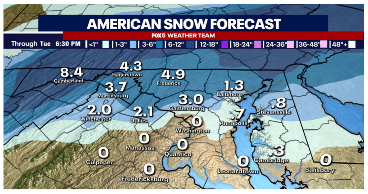
Winter weather in DC, Maryland & Virginia: How much snow have we seen?
Originally, it was anticipated that this storm would pass north of our area, resulting in only rainfall. However, recent trends indicate that the storm is shifting southwards, allowing cold air to wrap around its backside. As a result, there will be a temporary changeover from rain to snow on Tuesday morning. Winter weather advisories have been issued for a significant portion of our region, excluding the Washington, D.C. metro area.
How much snow will DC get Tuesday?
Forecasting events like this one can be quite challenging.
The D.C. area frequently faces challenges in bringing in sufficiently cold air as quickly as anticipated by weather models due to the presence of mountains to the north and west of our region. As a result, we often experience a mix of precipitation rather than pure snow.
Potential Nor’easter eyes Boston: Major cities could see a foot of snow
A potential Nor’easter is heading towards Boston, with major cities along the East Coast bracing for a significant snowfall. The storm could bring up to a foot of snow, causing travel disruptions and hazardous conditions.
Meteorologists are closely monitoring the developing system, which is expected to intensify as it moves up the coast. The storm is projected to impact a wide area, including cities such as New York, Philadelphia, and Washington, D.C.
Residents are advised to prepare for the possibility of heavy snowfall and gusty winds. Travel may be difficult, and power outages are a concern. Local authorities are urging people to stay updated on the latest weather forecasts and to take necessary precautions.
In anticipation of the storm, transportation agencies are already taking steps to minimize disruptions. Airlines are waiving change fees for travelers affected by the weather, and snow plows are ready to clear roads and highways.
This potential Nor’easter serves as a reminder of the unpredictable nature of winter weather. It is important for individuals to stay informed and be prepared for sudden changes in conditions.
The different models provide us with a variety of solutions. For instance, according to the American model, downtown D.C. receives no snow, while Frederick, Maryland gets nearly 5 inches.
In contrast, there are other models, like our Futurecast above, that indicate a swift dusting of snow, but with significantly less accumulation to the northwest of D.C. Meteorologists often refer to these types of events as “boom” or “bust” scenarios.
There is a potential risk of experiencing a wintry mix in the morning, although the certainty of the amount of snowfall remains uncertain.
In the advisory zone northwest of the city, we are anticipating 1-3″ of snow.
Snowfall totals exceeding an inch are expected in Loudoun, Montgomery, and northern areas during the Tuesday morning commute, potentially leading to treacherous travel conditions.
It wouldn’t be surprising to witness several schools in this area experiencing delays as they wait to see how the event unfolds in the morning.
In the immediate D.C. area, we believe there will be a brief changeover to a mix of snow. However, unlike the areas northwest of town, we don’t expect it to last as long. Nevertheless, there may be enough snowfall to result in a coating or possibly a bit more.
During the late morning hours, the system is expected to move away towards the northeast of our region. As a result, we can anticipate skies clearing up and giving way to some sunshine during the lunchtime hours. It is important to note that despite the clearing skies, the weather will remain chilly and breezy throughout this period.
Also Read:
- Police in DC identify man who was fatally shot in quadruple shooting
- Identity of man shot by police in Southeast DC revealed


