A Frost Advisory is currently in effect, set to expire at 8 a.m. Temperatures have dropped into the mid-to-upper 30s for several locations, with a few areas slightly warmer in the lower 40s. Compared to yesterday, temperatures are nearly five to 15 degrees warmer. As you head out this morning, you may notice a slight frost on your windshield, so it’s a good idea to warm up your vehicle for a few minutes before leaving for work or school. Fortunately, the majority of areas are still above freezing.
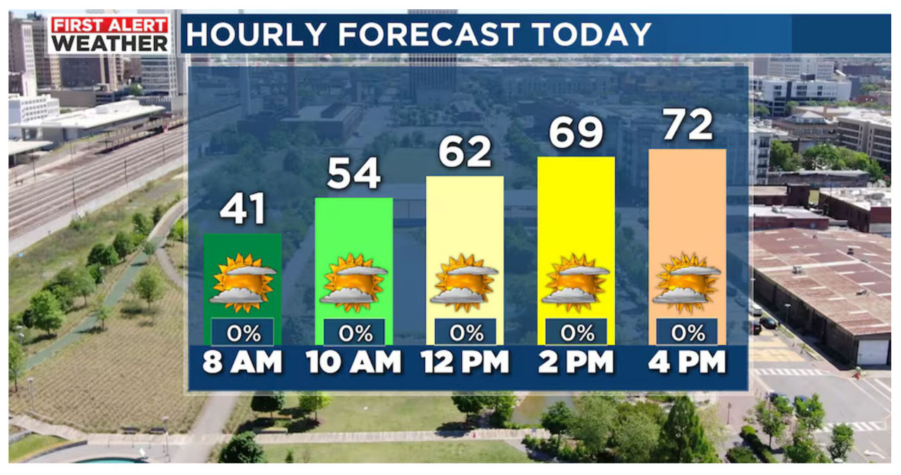
According to the latest update from the First Alert AccuTrack Satellite and Radar, the weather conditions are mostly clear and dry. Cloud cover in Arkansas and Louisiana is moving eastward this morning, resulting in an expected increase in clouds throughout the day. However, the good news is that we can expect to stay dry, and temperatures will be getting warmer as we embrace the first full day of spring. High temperatures are predicted to reach the lower 70s. A gentle breeze from the west-southwest, blowing at five to 10 mph, will accompany us today. If you have any plans for the evening, there’s no need to worry about rain as we can expect a partly cloudy sky. As the evening progresses, temperatures will cool down to the low to mid-60s by 7 to 8 p.m.
Thursday’s weather is expected to be mostly cloudy, with temperatures in the mid-40s when we wake up in the morning.
Tomorrow morning, there shouldn’t be any concern about frost. Thursday is expected to be dry with mostly cloudy skies. The afternoon temperatures are projected to reach the mid-70s, accompanied by east-southeast winds at five to 10 mph. Although there is a slight possibility of a stray shower late in the evening, the majority of us should stay dry.
Next Big Thing: Our forecast predicts the movement of an area of low pressure that will pass through the Southeast on Friday. This weather system is expected to bring scattered showers and steady rainfall to central Alabama during the afternoon and evening hours. Cloudy conditions will persist throughout Friday, with morning temperatures ranging from the low to mid 50s. While showers may be isolated in the early morning, there is a 70% chance of rain in the afternoon and evening. It’s important to be prepared for wet roads and reduced visibility as the rain could be steady.
The weather pattern is shifting, bringing in easterly winds and higher chances of rain. As a result, temperatures are expected to cool down on Friday afternoon, with most areas experiencing temperatures in the lower 60s. In some parts of northeast Alabama, temperatures may even stay in the mid-to-upper 50s. While severe weather is not anticipated, there is a possibility of isolated thunderstorms occurring south of Interstate 20. Additionally, we can expect to receive about half an inch to an inch of rainfall from Friday through Saturday morning.
This weekend’s weather forecast indicates a 20% chance of showers early on Saturday morning. However, most of Saturday is expected to remain dry, with temperatures cooling into the lower 50s in the morning and a cloudy sky. As the day progresses, the cloud cover is likely to decrease, resulting in a partly cloudy to mostly sunny sky. During the afternoon, temperatures will warm up to the mid 60s, accompanied by breezy conditions. If you have any evening plans on Saturday, it’s advisable to bring a jacket as temperatures will cool into the 40s at night. There is a possibility of temperatures dropping into the upper 30s on Sunday morning. Sunday will start off mostly sunny, with clouds gradually increasing later in the day. Temperatures are expected to warm up to the lower 70s, and no rain is expected on Sunday.
Looking Ahead:
Next week’s temperatures are expected to be close to average, with highs in the mid-to-upper 60s and lows in the 40s and 50s. Our next opportunity for rainfall is likely to occur on Tuesday as a cold front moves into the Southeast. While there is a low chance of seeing strong storms with this system, the stable atmosphere is expected to limit the threat of severe weather. Rain is expected to move through the area on Tuesday and could linger into the first half of Wednesday. Additionally, this system may bring windy conditions across the state. We will have a better understanding of the severe potential over the weekend, so stay tuned for updates throughout the week.


