Mocobizscene- AccuWeather’s latest forecasts suggest that the brewing weekend storm has the potential to transform into a “bomb cyclone.”
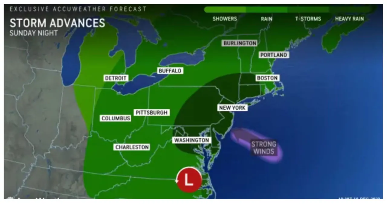
According to AccuWeather chief on-air meteorologist Bernie Rayno, this system will start off resembling a tropical storm as it rapidly moves northward on Sunday and Monday. It will bring strong winds and the potential for flooding to a large portion of New York state and the entire East Coast.
The potential danger of a bomb cyclone.
The storm is moving northward and gaining strength, possibly reaching the official classification of a bomb cyclone.
A bomb cyclone is a term used to describe a storm that is undergoing “bombogenesis,” which means it is rapidly intensifying. In simpler terms, it is a storm that is strengthening explosively.
According to AccuWeather, when a storm gains strength, the rising air creates a vacuum effect that leads to lower atmospheric pressure.
“Storms always have lower atmospheric pressure, but in this particular case, the atmospheric pressure is decreasing rapidly as the storm system strengthens,” explained Jon Porter, the chief meteorologist at AccuWeather. “The barometric pressure will significantly drop in a short period of time.”
According to AccuWeather, for a storm to be officially classified as a bomb cyclone, its central barometric pressure must drop by 0.71 of an inch of mercury (24 millibars) or more within a 24-hour period.
According to meteorologist Rayno, there is a potential for damage along the mid-Atlantic and New England coasts due to the rapid intensification of this storm. As the storm strengthens, it will generate strong winds that will push water from the Atlantic towards the shoreline. Additionally, heavy rainfall is expected. Wind gusts are anticipated to range between 40 and 60 mph, with the possibility of reaching 70 mph along the coast.
AccuWeather classifies these powerful gusts as winds near hurricane-level, reaching speeds of 74 mph or greater.
“A Warning from Hochul”
New York Governor Kathy Hochul has issued a statement urging all New Yorkers to prepare as the threat of these winds looms.
According to Hochul, the weather system over the weekend is expected to generate heavy rainfall, with up to three inches of rain. This could result in flooding in various areas, including the eastern Catskills, southern Capital Region, and possibly Long Island.
According to AccuWeather, the significant rate of rain can overwhelm storm drains, leading to roadway flooding. The rain can fall at a rate of half-an-inch per hour or even greater, posing a potential flood risk.
Coastal beach communities may experience moderate flooding due to the convergence of heavy rainfall and a surge of water from the Atlantic, according to AccuWeather. This combination poses a heightened risk of flooding, especially during high tide. The most severe weather conditions are anticipated on Sunday night.
Hochul emphasized the potential impact of strong winds, with forecasts predicting gusts of up to 50 mph in New York City. She warned that these powerful winds could lead to local power outages.
“We are closely monitoring a weather system that is bringing strong winds and heavy rain to various parts of the state, which could potentially lead to flooding and power outages for the people of New York,” Hochul stated. She further added, “I have instructed state agencies to closely track the progress of this weather system and I strongly urge all New Yorkers to prioritize their safety by taking necessary precautions and staying updated with the forecast throughout the weekend and into the beginning of next week.”
WHIPPED UP WEATHER
According to AccuWeather, New York is expected to receive a rainfall ranging from one to four inches, with at least two inches predicted for New York City. It’s important to note that flooding may not be confined to coastal areas and roads alone, as rivers in southeastern New York could also see minor to moderate flooding.
The National Weather Service (NWS) has once again turned its attention to the winds and acknowledged the potential danger of this weather phenomenon. As a result, an official wind advisory has been issued for Staten Island, Manhattan, and various other areas in the state. This advisory will be in effect from midnight on Sunday until noon on Monday.
The National Weather Service (NWS) has issued a high wind watch for several areas including Brooklyn, Queens, and Long Island. This watch will be in effect from late Sunday night until Monday morning.
Notify NYC recently issued an alert to New Yorkers about the upcoming weather conditions. The National Weather Service (NWS) has issued a wind advisory, with anticipated wind speeds of 20-30 mph and gusts up to 50 mph. The advisory warned that these strong winds could cause debris to be airborne and turn unsecured objects into dangerous projectiles. It’s definitely not the kind of weather Santa would want to fly in.
Here is our updated briefing (Briefing #2) for the storm to impact the region tomorrow night into Monday. Click the link for the full briefing: https://t.co/63018cuBqg#nycwx #nywx #njwx #liwx #ctwx #hvwx pic.twitter.com/VhVhemQbUS
— NWS New York NY (@NWSNewYorkNY) December 16, 2023
After the Storm
According to AccuWeather, the storm will continue until Monday, causing disruptions during the morning commute.
There is a possibility of more power outages as the winds change direction. This is because trees can move due to the saturated soil, causing them to break off large, waterlogged limbs.
AccuWeather forecasts that the storm may not bring significant snowfall initially. However, there is a possibility of flurries, snow squalls, and bands of lake-effect snow developing from the upper Midwest to the Appalachians on Monday and Tuesday. There is even a chance that snow showers could reach as far south and east as the I-95 mid-Atlantic zone late Monday night into Tuesday.
According to the AccuWeather forecast, on Monday, there could be a mix of rain and snow showers in Buffalo and the western parts of the state. Similarly, on Tuesday, New York City can anticipate rain and potential snow showers.
According to AccuWeather, the temperatures in New York City will be mild on Sunday and Monday, with highs reaching the upper 50s. However, the low temperature on Sunday is expected to be 52 degrees, while Monday will be cooler at 38 degrees.
According to AccuWeather, there will be a significant change in weather on Tuesday, with a high of 41 and a low of 32. However, the sunshine will make a comeback by Wednesday, accompanied by a high of 43 and a low of 36.
Also Read:
- Weeklong Forecast for Miami Predicts Storms, Rain, and Strong Winds
- Severe Storms Cause Widespread Tree And Power Line Damage In Central Alabama On Sunday
- Connecticut Experiences Its Largest Christmas Snowstorm in History


