Yesterday’s strong winds and storm threat have subsided, giving us a two-day period of tranquility. The only notable aspect of the weather during this time is the cooler-than-usual temperatures.
Winter is not done yet for some parts of the Upper Peninsula, as a Winter Storm Warning has been issued. The Houghton area in Michigan’s Keweenaw Peninsula is expected to receive up to a foot of snow between today and Thursday. The National Weather Service in Marquette has also warned about high winds and white-out conditions on the roadways in the area.
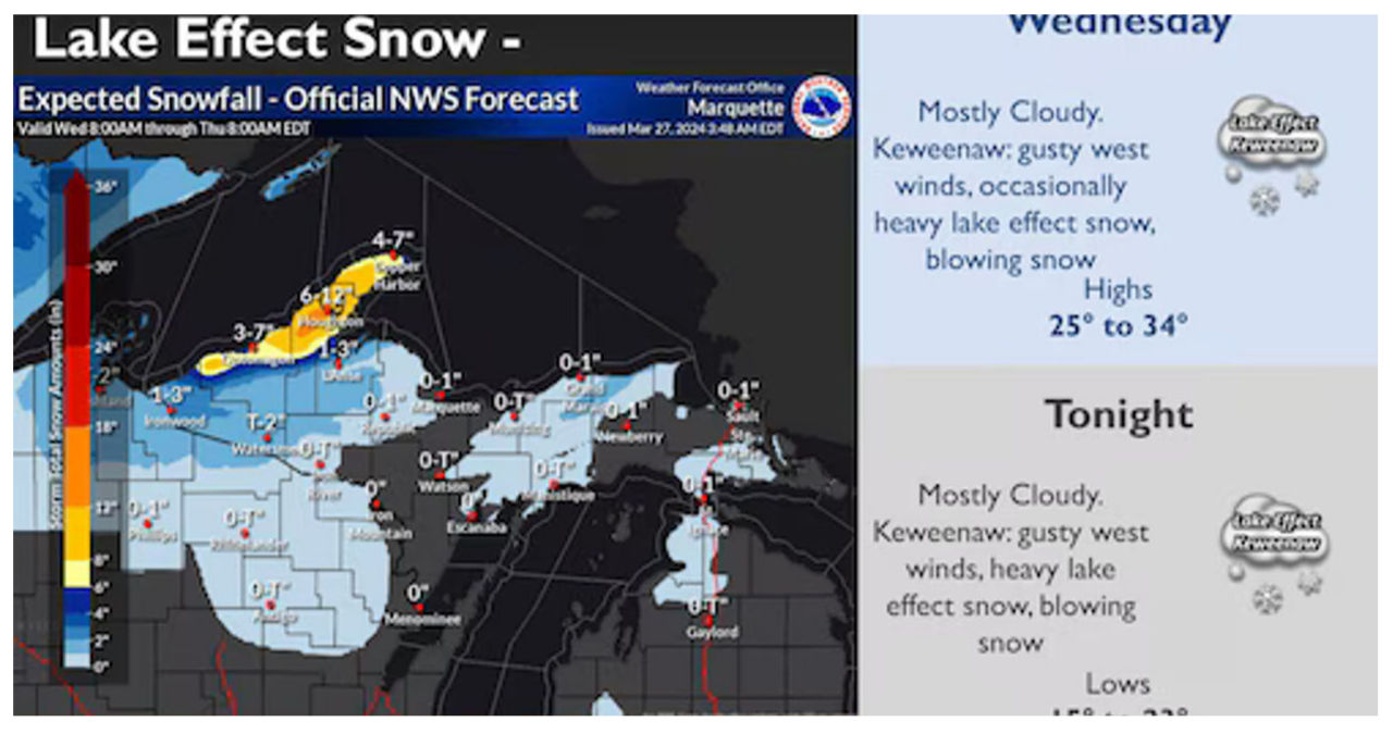
According to meteorologists from the office, there will be a significant increase in the intensity of lake effect snow showers in northwest Upper Michigan this afternoon and tonight. They are expecting a foot or more of snow accumulation over certain areas of the northwest region, particularly from Twin Lakes to Painesdale, through early Thursday. Additionally, strong west winds with gusts of 35 to 40 mph will contribute to occasional whiteout conditions due to blowing snow.
The National Weather Service has upgraded the Winter Weather Advisory to a Winter Storm Warning in the area of Houghton and Hancock, which is home to Michigan Technological University.
-
- The winter storm warning goes into effect at 2 p.m. Wednesday and lasts until 8 a.m. Thursday
- Travel could be difficult at times, especially the Wednesday night and Thursday morning commutes
According to the weather forecast, there is a prediction of heavy lake effect snow in the area, particularly in the late afternoon and evening. By Thursday morning, it is anticipated that there will be snow accumulations ranging from 6 to 10 inches, with higher amounts of 10 to 13 inches in the elevated areas such as Twin Lakes and Houghton, including South Range, Painesdale, and Toivola. Additionally, strong west winds are expected with gusts reaching up to 40 mph during the day and up to 35 mph at night.
Get ready for some serious lake-effect snowbelt action on the horizon. While areas to the south of the Keweenaw may see a moderate 1 to 3 inches of snow, the real winter wonderland is expected to hit the peninsula bounded by Lake Superior. Brace yourself for the snowfall of a lifetime.


