The Weather Authority is closely monitoring the potential for strong to severe storms on Saturday afternoon and evening in Huntsville, Alabama.
The Storm Prediction Center (SPC) has issued a Tornado Watch for the area overnight in anticipation of the approaching system.
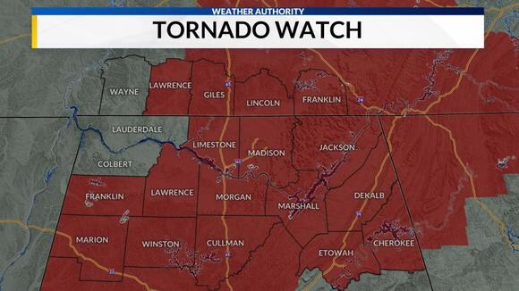
A Tornado Watch has been issued for Franklin, Lawrence, Lincoln (TN), Madison, and Morgan counties until 11 pm.
There is currently a Tornado Watch in effect for DeKalb, Jackson, and Marshall counties until 3 am Sunday.
There is a slight possibility of a tornado occurring due to the presence of warm air, high dew point values, instability, and wind shear.

The risk level for severe storms in Far NW Alabama has been upgraded to an ‘Enhanced Risk’ (level 3 out of 5), while the rest of the area remains under a ‘Slight Risk’ (level 2 out of 5). The highest risk for strong to severe storms is expected along and west of I-65.
Get ready for a potentially intense weather event this Saturday as a severe storm is expected to hit.
Storms will present several main threats, including damaging winds, heavy rain, and a low-end risk of tornadoes. It is important to closely monitor areas along and west of I-65, as these regions have a higher likelihood of tornado development. In addition to strong gusts during the storms, wind speeds will reach up to 25 to 30 mph.
Read More:
- Alabama police officer placed on leave after video shows her using stun gun on handcuffed Black man
- Senators are dealing with aftershocks of Tuberville blockade