On June 17th, the South Fork and Salt fires started, as captured by a live camera set up by Ruidoso EarthCam, providing a view of the Village of Ruidoso. The city of Ruidoso shared the photo as proof of the wildfires’ occurrence.
According to a recent forecast, the early monsoon rains in southern New Mexico played a crucial role in helping firefighters gain control over the South Fork and Salt fires. These rains were part of a larger weather pattern throughout the state that is expected to decrease the risk of wildfires over the next few weeks.
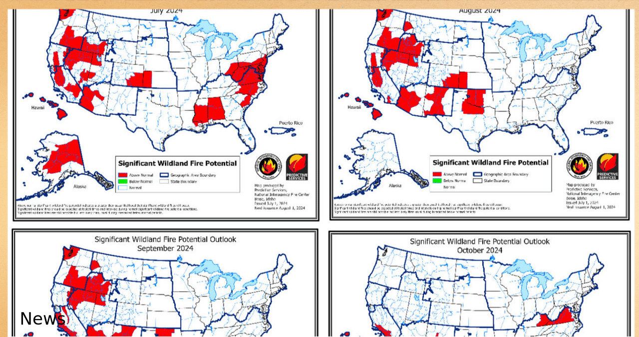
According to the National Interagency Fire Center’s monthly outlook, forecasters are warning that the risk of wildfires will make a strong comeback later this month and could persist throughout the fall season.
The center has predicted that the risk of fire will exceed the usual levels from late July through August, specifically along the Continental Divide and to the east. The outlook suggests that the weather will remain hot and dry throughout the month with little respite expected in September.
According to the outlook, the high risk could persist for a longer period than expected, possibly up until October.
According to the NIFC outlook for July, which was released in May, hot and dry conditions are expected in most parts of the state, including central New Mexico along the mountain ranges and southern New Mexico. These conditions are likely to increase the risk of fire, surpassing the normal levels.
According to statistics from the Southwest Coordination Center, there have been a total of 437 wildfires reported across the state this year. These fires have combined to burn 62,654 acres of land. Out of the reported fires, 97 were caused by lightning strikes, 269 were caused by human activity, and the cause of the remaining 71 fires is still unknown, according to the center.
According to state officials, the South Fork and Salt Fires, which started on June 17, rapidly became hazardous, causing harm to around 1,400 structures and claiming the lives of two individuals.
On June 19th, a rainstorm swept through the region. While it aided in increasing moisture and diminishing the fire’s expansion, it also resulted in flash floods and debris flows in and around the burn scar.
Public records and lightning data shed new light on Salt and South Fork fire origins
On Tuesday, the fires’ containment level reached 85%. George Ducker, a spokesperson for state forestry, stated that the remaining hot spots within the fire perimeters are not expected to be a significant threat thanks to scattered moisture. He added that these hot spots will remain dormant until a drying trend occurs.
The incident command team responsible for the fires has stated that the causes of both fires are still unknown. However, investigators are currently working diligently to determine what ignited the tragic flames, with the assistance of the Federal Bureau of Investigation.


