Experts are continuing to predict a highly active hurricane season for Florida and other areas of the Atlantic and Gulf coasts, causing insurers, utilities, and emergency-management officials to brace themselves for the coming months.
The National Oceanic and Atmospheric Administration (NOAA) reiterated previous forecasts for the upcoming hurricane season, which is set to begin on June 1. They highlighted the presence of warm ocean waters as a contributing factor and projected a potential of up to 25 named storms. Out of these, they anticipate that between 13 and 25 could reach hurricane strength, with four to seven potentially developing into Category 3 or stronger storms.
According to Mark Wool, the warning coordination meteorologist at the National Weather Service’s Tallahassee office, the latest forecast inspires a high level of confidence. However, it is important to note that the forecast does not provide specific paths of storms or predict potential landfalls.
According to meteorologist Wool, all the necessary elements for hurricane formation are present. The Atlantic tropical-development areas still have near-record warm waters, similar to the conditions observed last year. Additionally, the absence of the El Nino climate pattern is favorable for hurricane development. Interestingly, an El Nino during hurricane season increases wind shear over the development areas, which is beneficial for minimizing hurricane formation.
Officials are increasingly worried about the more frequent occurrence of rapid intensification of storms. This trend leaves less time for necessary preparations and evacuations.
According to Wool, climate change does not necessarily imply an increase in the average number of tropical cyclones. However, the prediction is that there will be a rise in the occurrence of major hurricanes, particularly category 4 and 5 storms. Wool also highlights that rapid intensification, which has been on the rise, will happen more frequently due to climate change.
“That’s taking a Category 1 storm to Category 3, almost to a Category 4. That’s significant. That what I’m talking about. The waters are warm again this year. We’re all cognizant of that as we’re going to prepare for this year.”
Armando Pimentel, president and CEO of Florida Power & Light
“That’s taking a Category 1 storm to Category 3, almost to a Category 4. That’s significant. That what I’m talking about. The waters are warm again this year. We’re all cognizant of that as we’re going to prepare for this year.”
The official start of the six-month hurricane season is June 1st. However, there was a disturbance off the eastern tip of Cuba on Thursday that had a low chance of developing into the first named system of the year.
State Division of Emergency Management Director Kevin Guthrie recently acknowledged the potential for a highly active hurricane season. He emphasized that responding to hurricanes is an area where they excel, stating that it is something they do better than anything else.
According to Guthrie, the division has made preparations for the possibility of up to five storms striking the state. In anticipation of these storms, they plan to depend more on contractors for the provision of materials before and after the storm, as compared to previous years.
Guthrie explained that they have made significant changes in their logistics operations as they prepare for the upcoming season. Previously, they had five logistics vendors, but now they have expanded their network to include 12 logistics vendors. This expansion reflects their commitment to improving their logistical capabilities and ensuring a smooth and efficient operation for the upcoming season.
Florida State University Climatologist David Zierden noted that the predictions of a busy season did not catch anyone off guard due to the warm ocean temperatures.
According to Zierden, the sea surface temperatures in the main development region are currently as warm as they typically are in mid-August. He noted that last year, the sea surface temperatures in that region were record warm, and this year they are even higher as we enter the hurricane season.
Both the NOAA forecast and the Colorado State University Department of Atmospheric Science forecast predict a similar outcome. According to both forecasts, there could be 23 named storms and 11 hurricanes.
According to the University of Pennsylvania’s School of Arts & Sciences experts, there will be a staggering 33 named storms in the forecast.
AccuWeather, a private meteorology company, issued a warning on Wednesday regarding the rapid intensification of storms. These storms have the ability to increase their wind intensity by at least 35 mph within a span of 24 hours or less.
According to AccuWeather Lead Hurricane Forecaster Alex DaSilva, there have been numerous instances in recent years where wind speed records have been surpassed. In a prepared statement, DaSilva noted that there have been cases of wind speeds increasing by as much as 40 mph, 50 mph, and even 60 mph within a span of just 24 hours.
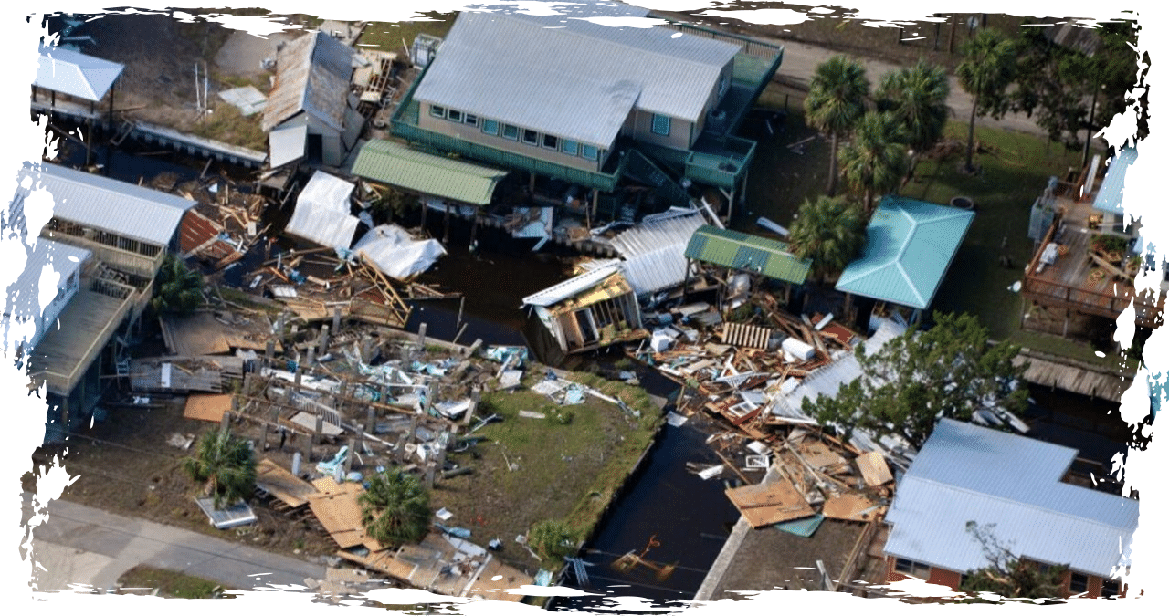
In 2022, Hurricane Ian serves as a prime example of a rapid intensification event. Within a mere 24 hours, this hurricane transformed from a Category 3 system with wind speeds of 120 mph to a Category 5 powerhouse with wind speeds reaching 160 mph. Consequently, it made landfall in Southwest Florida as a destructive Category 4 storm.
“I’m pretty optimistic that one storm is not going to kill us. A couple of storms may be a little bit more of an issue. If this is a season where we have two or three hurricanes, we’re going to be facing some concerns.”
Patricia Born, professor of risk management and insurance at Florida State University
“I’m pretty optimistic that one storm is not going to kill us. A couple of storms may be a little bit more of an issue. If this is a season where we have two or three hurricanes, we’re going to be facing some concerns.”
The 2023 season proved to be one of the busiest on record, witnessing the formation of 20 named storms, with seven of them intensifying into hurricanes and three reaching major hurricane status. Towards the end of August, Hurricane Idalia struck Taylor County as a powerful Category 3 storm, causing widespread destruction across rural areas of North Florida.
The Atlantic has witnessed an average of 14.4 storms per year from 1991 to 2020, with approximately 7.2 of them intensifying into hurricanes.
During a meeting with the state Public Service Commission, Armando Pimentel, the president and CEO of Florida Power & Light, emphasized the need for the utility to be prepared for storms that may rapidly escalate in intensity. Pimentel expressed his concerns, stating that the utility can no longer rely on the assumption that a Category 1 storm will remain as such.
Pimentel emphasized that the situation was different two decades ago and acknowledged that recent events may have been a series of coincidences. However, he stressed the importance of being fully prepared for any future occurrences.
According to Pimentel, Hurricane Idalia’s maximum sustained winds intensified by 55 mph within a span of 24 hours prior to making landfall.
Pimentel emphasized the significance of a Category 1 storm intensifying to a Category 3, and potentially even reaching Category 4. He highlighted the warm waters as a factor contributing to this increase in intensity. Pimentel also acknowledged the need to be aware of this trend and adequately prepare for the upcoming year.
According to Patricia Born, a risk management and insurance professor at Florida State University, recent changes have been beneficial for the property insurance market. This includes legislation that has provided support to insurers and the backing of reinsurers. As hurricane season approaches, Born highlighted that residents of Florida have the option to obtain coverage from private insurers or through the state’s Citizens Property Insurance Corp.
According to Born, it is reassuring to know that there isn’t a significant number of uninsured individuals as we approach the season. This observation holds importance from a social standpoint.
However, Born warned that there are still challenges ahead for the state in terms of storms impacting homeowners’ insurance premiums. According to Born, the issue lies in navigating through a transitional period before the legislation takes complete effect.
According to Born, he remains optimistic despite the potential challenges that may arise from multiple storms. He believes that while one storm may not pose a significant threat, the situation may become more problematic if the season brings two or three hurricanes. In such a scenario, concerns would undoubtedly arise.


